Projects

Finite Differencing

heun-runge-kutta-still

Finite differencing is an explicit numerical means of solving spatial and temporal derivatives. I’ll show you the math that allows us to predict the future!

Come with me on a fantastic journey through time and space!

Radar Design

Radar Design
Radar Design

A team project where money was no object, our task was to design a custom Doppler radar system for the greater Boston area. We determined the bounds of our system by studying the dominant weather patterns of the region and a selection of severe weather case studies. For both the extreme events, and the more typical conditions, the challenge was to strike a balance between output sounding resolution and update speed, between creating research-grade products and maintaining everyday functionality.

Charlotte Storm Water

Charlotte Storm Water

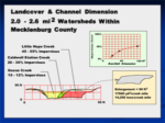
Since its inception, stream restoration has been guided by the Rosgen stream classification system. Typical parameters include cross-sectional dimension, channel and valley shape, grade, sinuosity, stream features, channel material distribution, and geographic setting. While integral, this system is limited to (quasi)static streams. With the great majority of our work at Habitat Assessment & Restoration Professionals was done in urban(izing) settings, whose watersheds contain large areas of impervious cover (and are thus highly susceptible to flash flooding and frequent channel modification), we find this system to be severely lacking in its present state. With this study, Dr. Forsythe seeks to improve upon this (otherwise beneficial) status quo.

Green Roof

The Biology Department turned to Dr. Forsythe for help in determining how best to study the local environmental effects of green roofs. I employed the use of Erdas Imagine on aerial photography to come up with an unsupervised land-use classification map that delineated a number of different land-surface types. This would allow them to choose an appropriate local diversity of locations across the city. We also helped set up their control study, measuring in situ surface properties such as temperature, thermal inertia, and humidity.

Charlotte Mecklenburg Utilities ArcGIS

Given a list of addresses where grease blockages had been found and cleared from sewers over the four-year time-span, I created a color-coded map of grease spills for CMU using ArcGIS.

CH2MHill

CMU brought CH2MHill in to investigate the cause of persistent complaints of odor logged at certain locations in Charlotte. They proposed that the odor was due to sewage that was not moving quickly enough through the system. This was allowing bacteria to build up at these points of stagnation. I was contracted through the UNC-Charlotte Environmental Assistance Office to collect construction as-built plans of nearby sewer lines. I was responsible for mapping the grade of these individual pipes and flagging areas of shallow slope.

GIS Network Path Analysis

Dr. Wei-Ning Xiang’s final class project required each student to build a GIS database with an easy-to-use interface that could perform purpose-driven tasks. I chose to create a tool that would show the most efficient path to walk from any point on campus to any other. Creation of the database involved digitally tracing out a vector network of sidewalks, paths, and stairs using aerial photography, and subjectively assigning weights to paths with subtle barriers such as path grade. I later included an accessibility option that completely shut off paths that could not be traveled by wheelchair.

NDVI

AVHRR Imagery
AVHRR Imagery

For several months, I collected Advanced Very High Resolution Radiometer (AVHRR) polar-orbiting satellite data using a small radar dish on the roof of Dr. Forsythe’s lab. During this acquisition period, I sorted through hundreds of images captured from multiple satellites and geometrically corrected those remaining using Erdas Imagine. A Normalized Differential Vegetation Index (NDVI) was achieved by calculating specific differences between satellite sensor spectral channel-1 (ρRED -> 0.58-0.68µm) and near-infrared channel-2 (ρNIR -> 0.725-1.0µm).